
Te Ihingarangi – Part 7
-
Part 7 of a history of the Karapiro-Maungatautari area by Te Kaapo Clark and Lyn Tairi.
1800
KO NGATI RAUKAWA, NGATIKOROKI, NGATI WAIRERE, NGATI HAUA
The Reverend Alfred Brown, from Tauranga, and James Hamlin were the first Pākehā to visit the area in 1834. Brown made regular trips between 1834 and 1849 to preach the Christian message. During this period Ngāti Koroki flourished and prospered. Throughout the area they had extensive cultivations of wheat and potatoes and raised cattle and pigs for trade. Bishop Selwyn recorded in December 1842 that he “walked several miles through native cultivations and wheat fields of very considerable extent.” By 1857 Whareturere, one of the principal kainga, had a stock yard for cattle, a chapel, a mill house, plough, carts and immense wheat plantations.
Whareturere also had its own courthouse. This belonged to Tioriori, the principal chief of Ngāti Koroki, who had been appointed as an assessor by F D Fenton, Resident Magistrate of Waikato, to administer law and order in the Maungatatari area. Tioriori also travelled around the Waikato and to Taranaki with Wiremu Tamihana, trying to keep the peace between Māori and Pākehā.
Several other kainga in the area can also be identified: Nga Totara, Te Wera a to Atua, Ihapa and Wharepapa were all inhabited and prospered during this period. Other places in the Pukekura/Maungatautari area were identified by claimants to the land at the 1873 Land Court hearing. Pukekura is the name of the block of land between the aukati boundary, the Hauoira Stream, and the Mangapiko Stream. However, only Mahuroa has been located, The other kainga mentioned are: Taurau, Motoa, Parapara, Tapaekairangi (probably Kairangi), Waipapa, Tauaroa, Kuruaro, Te Tapae and Ruapekapeka.
Te Manehu, Mangaroa (where the present marae is), Wareareki, Te Kakara, Wairengapoka and Te Reiwa were all sites of cultivations. Department of Conservation archaeological site records show areas of pits in the Pukekura region and along the river, near the Hauoira Stream. There were probably many more, but time and pastures have obliterated them. These pits were used for the storage of food, especially kumara.
Published in the Cambridge Historical Society Newsletter December 2021
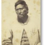
Tioriori, photograph from DigitalNZ