
Te Ihingarangi
-
Te Ihingarangi: a history of the Karapiro and Maungatautari area
by Te Kaapo Clark and Lyn Tairi
This timeline traces the whakapapa of the tangata whenua of Maungatautari. It is reproduced here with kind permission from Lyn Tairi.
Read the original here.
Choose a date from the timeline:
1300 1400 1500 1600 1700 1800 1900 2000 Native Land Court
1800a
1300
KO NGA WAKA TUPUNA
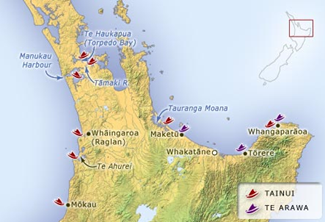
Map from Rāwiri Taonui, ‘Canoe traditions – Te Arawa and Tainui’, Te Ara – the Encyclopedia of New Zealand, Source (accessed 11 September 2020)
1300 is considered the approximate time of arrival of the third migration from Hawaiki. It is to the waka of this period that Maori today trace their whakapapa and iwi. The Tainui, Te Arawa, Mataatua, Kurahaupo, Tokomaru, Aotea and Takitumu are the seven most famous to arrive at this time.
Tainui and Te Arawa both arrived on the east coast of Aotearoa at Whangaparaoa. After a dispute about who arrived first, Hoturoa took Tainui and his people and sailed up the coast to Waitematā, then hauled the waka across the dividing land to Manukau on the west coast. Some members of the crew settled at Waitematā and their descendants spread south. Hoturoa then sailed down the coast to Whāingaroa (Raglan), Kāwhia and Mōkau.
Meanwhile the members of the Te Arawa crew spread inland quickly from the east coast. Ngatoroirangi, the tohunga of the Te Arawa, discovered, explored and named the mountains of the central plateau. Ihenga discovered and settled the Rotorua lake district, while Tamatakapua the commander of Te Arawa settled the area between Maketu and Rotorua. Their descendants spread inland to the Waikato and King Country.
1400
Ko Ngati Kahupungapunga
“Tawhao, a descendant of Hoturoa who lived at Whaingaroa, married Punuiatakore and Marutehiakina, who were sisters. Marutehiakina gave birth to a son, Whatihua, just before Punuiatakore gave birth to her son, Turongo. Intense rivalry grew between the brothers, both proclaiming they were tuakana; Whatihua because he was first born and Turongo because he was born to the first wife and elder sister. This rivalry culminated in Whatihua outwitting Turongo to gain the love of Ruaputahanga from Taranaki. Ruaputahanga was the daughter of Hou-tae-po and descendant from Turi, commander of the Aotea Waka.
After Whatihua had won Turongo’s fiancee and married her, Turongo left Whaingaroa. He travelled to Heretaunga (Hawkes Bay) where he fell in love with Mahinarangi, daughter of Tuaka and Te Angiangi and directly descended from both Kupe, of the Matahoura Waka and Paikea, of the Horouta Waka. When Mahinarangi and Turongo were married, Tawhao persuaded Turongo to return to Kawhia. Mahinarangi, who was pregnant, was to follow when Turongo had established a home.
Tawhao gave Turongo all his lands “on the eastern and inland side of the Pirongia and Hauturu ranges with the northern boundary on the Puniu River”1. Turongo, with some of his people, built a kainga on the banks of the Manga-o-rongo (near Otorohanga) and named his new house Rangiatea in memory of the homeland in Hawaiki. Mahinarangi started to make her journey to Rangiatea, but stopped at Okoroire (near Matamata) to give birth to her son, Raukawa.
This area was occupied by Ngāti Kahupungapunga; they had penetrated inland from the east coast and established settlements “at least six generations before the Tainui people penetrated inland.”2 Ngāti Kahupungapunga had spread north and south from Okoroire; down the Waikato River to the junction with the Waipa River (now Ngaruawahia), and to Otorohanga, Parawera, Atiamuri and Taupo.
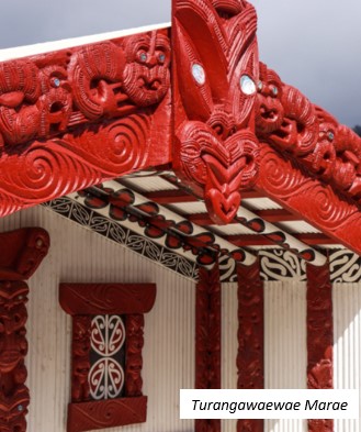
Thus Raukawa was born among his mother’s iwi. Raukawa was betrothed to Turongoihi who was probably born at the same time and place. After the birth, Mahinarangi continued her journey. Turongo met his family and took them home to Rangiatea where they lived peacefully with their neighbours, Ngāti Kahupungapunga. Turongo and Mahinarangi are commemorated by the houses that bear their names and stand side by side at Turangawaewae Marae.”
Published in the Cambridge Historical Society Newsletter December 2020.
1 Pei Te Hurinui, Mahinarangi: A Tainui Saga (Te Kuiti 1945) p12.
2 F.L. Phillips, Nga Tohua Tainui: Landmarks of Tainui (Otorohanga 1989) p22.
1500
Ko Ngati Kahupungapunga
“During this period Ngāti Kahupungapunga had many settlements along the Waikato River, including Karapiro. Towards the end of this century a Ngāti Kahupungapunga chief, Parahore, married a great-granddaughter of Turongo, Korokore. She apparently considered that she had married beneath her station. In any event she became so domineering that finally, when she ordered her husband to make a gift of preserved birds to her relatives, he turned upon her and silenced her forever with a blow of his war club.”1
Korokore’s slave escaped and conveyed the news to Whaita, Korokore’s brother. Whaita, with the help of his uncle Takihiku and cousins Tamatehura, Wairangi, Upokoiti and Pipito, exacted utu on the Ngāti Kahupungapunga. Battles were fought at Te Arowhenua, Te Pohue, Takaahiahi and Hapenui, which cleared the western side of the Waikato.1
On the eastern side Ngāti Kahupungapunga were relentlessly pursued and pa were captured at Piraunui, Hokio, Pawaiti and Puketotara along what is now Lake Arapuni. The last battle was fought at Pohaturoa, known today as Atiamuri Rock, on Lake Whakamaru, which Tainui besieged until the defenders were starved out and immediately killed. Tainui hapu took over the lands of the Ngāti Kahupungapunga.
“During this time descendants of Uenukuwhangai, youngest son of Whatihua and Ruaputahanga, went to Maungatautari, and settled on the western slopes near Puahue. It is not clear whether they were there before the war with Ngāti Kahupungapunga or whether they went there as a result of that war. They spread round Maungatautari on the northern side through Roto-o-rangi to the Cambridge district.”2
1 F L Phillips, Nga Tohua Tainui: Landmarks of Tainui (Otorohanga 1989) p50.
2 J B W Roberton, Maori Settlement of the Waikato District (Te Awamutu 1965) p21.
Illustration of Ngati Kahupungapunga from The Blade of the Club of Raukawa on raukawa.org.nz
1600
Ko Ngāti Raukawa
Te Ihingarangi, grandson of Raukawa and Turongo, and son of Rereahu and Rangianewa, built a home above the Waikato River at Karapiro (now known as Te Tiki o Te Ihingarangi). He had moved his people to this area of the Waikato after a dispute with his younger half-brother Maniapoto. Te Ihingarangi had originally lived at Ongarahu in the Waipa Valley, south east of Otorohanga. Just before his death Rereahu passed his mana and leadership to Maniapoto. Adding injury to insult, Maniapoto attacked Te Ihingarangi. After several of his warriors were killed Te Ihingarangi accepted defeat and moved his people to Maungatautari.1
There, Te Ihingarangi married Ringa-ariari and they had a son named Te Kuri. Te Ihingarangi, in later life, returned to Waipa. But Te Kuri remained in the Maungatautari area and married Whakamaungarangi, a descendent of Uenukuwhangai and of the Ngāti Kauwhata hapu. Te Ihingarangi’s people came to be known as Ngāti Raukawa and lived on the northern slopes of Maungatautari, spreading north through Karapiro and down the Waikato River towards Kirikiriroa.
The Maungatautati/Karapiro area grew in importance. Strategically it was a good defensive position. Hill top pa like Te Tiki o Te Ihingarangi commanded views of the Waikato basin. The area was also rich in food resources. Birds, especially kereru, and berries, especially tawa, taraire and hinau, were plentiful in the forests2. The swampy lowlands and the river provided flax, waterfowl and eels.
Also during this period Koroki came to prominence. He was directly descended from both Uenukuwhangai and Te Ihingarangi. Koroki “lived on the south side of the Waikato River near Cambridge.” 3 Taowhakairo, a Ngāti Kauwhata cousin of Koroki, lived on the northern bank of the river.
“When Taowhakairo found Koroki visiting his wife in his absence, he vowed to cook Koroki and eat him, an insult that could not be allowed to pass… Koroki called on his Waikato cousins for help and together they attacked and defeated Ngāti Kauwhata.”3
Koroki married two sisters, Kahurere and Tumataura, who were granddaughters of Tama-inu-po from Whatawhata. Tumataura and Koroki had two sons, Hape and Haua. Ngāti Koroki are descended through Hape, and Ngāti Haua through Haua. From Wairere, Kahurere and Tumataura’s father, Ngāti Wairere, are descended.
1F L Phillips, Nga Tohu a Tainui: Landmarks of Tainui (Otorohanga 1989), p30
2Richard Cassells, “Human Ecology in the Prehistoric Waikato”, Journal of the Polynesian Society Vol 81 (1972) p232
3J B W Roberton, Maori Settlement of the Waikato District (Te Awamutu 1965) p25
Published in the Cambridge Historical Society Newsletter April 2021
1700
KO NGATI RAUKAWA
During the 18th century the Maungatautari/Karapiro area was relatively peaceful and settled. Ngāti Raukawa dominated the Maungatautari slopes at the beginning of this period. One identifiable kainga of Ngāti Raukawa was Haowhenua (to the left of Luck at Last Road). Hape’s descendants spread along the southern side of the Waikato River, while Haua’s spread along the northern side and across to Matamata.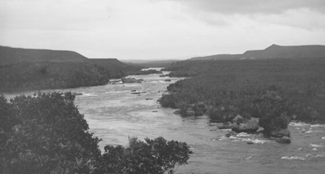
Waikato River between Cambridge and the Waotu Rapids. Beere, Daniel Manders, 1833-1909 :
Negatives of New Zealand and Australia. Ref: 1/2-096182-G. Alexander Turnbull Library,
Wellington, New Zealand. /records/23077211
1800
KO NGATI RAUKAWA, NGATIKOROKI, NGATI WAIRERE, NGATI HAUA
While no Pākehā had set foot in the Maungatautari/ Karapiro region until the 1830s, their presence in Aotearoa was felt there in the 1820s. The introduction of muskets to the Nga Puhi caused a great upheaval in the settlement patterns of the North Island.
Te Rauparaha, whose mother was of Ngāti Raukawa, from Maungatautari, was driven from his home at Kawhia by Waikato and Ngāti Maniapoto after many battles with these tribes. In 1822 Te Rauparaha persuaded his Ngāti Raukawa kin from Maungatautari to join his migration south “because he needed more fighting men.” Ngāti Kauwhata also went with their Ngāti Raukawa cousins.”
The vacant slopes of the mountain were soon filled by tribes from Hauraki. They had been driven from their homelands by Nga Puhi raiders, led by Hongi Hika, The Nga Puhi possessed muskets and were quickly able to defeat their foe who did not. The Ngāti Marutuahu (Maru) built 15 pa between Tauwhare and Maungatautari. One of the largest was Haowhenua — the kainga vacated by Ngāti Raukawa. Ngāti Maru enlarged and fortified the site. Its area covered 15 acres and held “three thousand … warriors … [with] a proportionate number of women and children, old men and slaves.”
Ngāti Haua and Ngāti Koroki had allowed the refugees to settle, but “Ngāti Marutuahu’s aims [soon] became starkly apparent. Behaving like the proverbial cuckoos in the nest they began to plunder friendly neighbouring villages…. Soon murders, skirmishes, pitched battles and massacres became almost daily events, neither side gaining any marked advantage.”
All this culminated in the Battle of Taumatawiwi in December 1830, where Te Waharoa of Ngāti Haua was able to defeat the Ngāti Maru with his superior military skill and the help of one thousand Ngaiterangi warriors from Tauranga. After peace was sued for, the Ngāti Maru were escorted out of the Waikato and then sent home to Hauraki. Te Waharoa “then entrusted the kindred Ngāti Koroki tribe with the guardianship of the mountain and returned to Matamata.”
It is from the Battle of Taumatawiwi that Karapiro gets its name. Kara means rocks and piro means smell or odour. After the battle Te Waharoa was worried about a counter attack from the Ngāti Marutuahu, so that night he burnt the bodies of his dead warriors “lest they fall into the enemy’s hands” — which would indeed cause a very strong smell. This took place on a large outcrop of rocks, near the edge of the river. Most were flooded when the dam was built. Then in 1975 they were removed to make way for the rowing course for the 1978 world rowing championships. One rock is now situated at Maungatautari Marae and the others at Karapiro Domain.
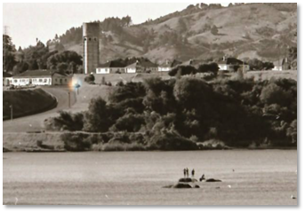
The rocks at Karapiro in 1966
The Reverend Alfred Brown, from Tauranga, and James Hamlin were the first Pākehā to visit the area in 1834. Brown made regular trips between 1834 and 1849 to preach the Christian message. During this period Ngāti Koroki flourished and prospered. Throughout the area they had extensive cultivations of wheat and potatoes and raised cattle and pigs for trade. Bishop Selwyn recorded in December 1842 that he “walked several miles through native cultivations and wheat fields of very considerable extent.” By 1857 Whareturere, one of the principal kainga, had a stock yard for cattle, a chapel, a mill house, plough, carts and immense wheat plantations.
Whareturere also had its own courthouse. This belonged to Tioriori, the principal chief of Ngāti Koroki, who had been appointed as an assessor by F D Fenton, Resident Magistrate of Waikato, to administer law and order in the Maungatatari area. Tioriori also travelled around the Waikato and to Taranaki with Wiremu Tamihana, trying to keep the peace between Māori and Pākehā.
Several other kainga in the area can also be identified: Nga Totara, Te Wera a to Atua, Ihapa and Wharepapa were all inhabited and prospered during this period. Other places in the Pukekura/Maungatautari area were identified by claimants to the land at the 1873 Land Court hearing. Pukekura is the name of the block of land between the aukati boundary, the Hauoira Stream, and the Mangapiko Stream. However, only Mahuroa has been located, The other kainga mentioned are: Taurau, Motoa, Parapara, Tapaekairangi (probably Kairangi), Waipapa, Tauaroa, Kuruaro, Te Tapae and Ruapekapeka.
Te Manehu, Mangaroa (where the present marae is), Wareareki, Te Kakara, Wairengapoka and Te Reiwa were all sites of cultivations. Department of Conservation archaeological site records show areas of pits in the Pukekura region and along the river, near the Hauoira Stream. There were probably many more, but time and pastures have obliterated them. These pits were used for the storage of food, especially kumara.
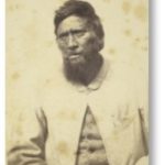
Portrait of Tioriori, principal chief of Ngāti Koroki of Maungatautari, 1863. Source: Auckland Libraries Heritage Collections 661-24 (view source)
In 1846 a flour mill was built and in 1852 another was built because Ngāti Koroki “had extended their growing to such a scale that their mill could no longer cope with the harvest and in consequence they planned a further one, as well as a brick oven for bread, the whole to cost £350….”
In 1856 Mr and Mrs James Shepherd set up a trading store about half a mile from Whareturere. Mrs Shepherd recorded in her diary, “we sent several tons of bacon and flour to Auckland… All the bacon was cured for us before it was packed in flax kits for the market… Maungatautari was a most prolific place with large plantations of raspberries… and large groves of peach trees.”
By 1859 the situation had begun to change. Mrs Shepherd noticed the people were worried about the situation in Taranaki, where a dispute had arisen over land sales. Tension was also increasing in the Waikato as Pakeha wanted more land, and had become uneasy over the establishment the Māori King Movement in 1858.
Hostilities broke out after General Duncan Cameron’s troops crossed the Mangatawhiri River (at Meremere) on 12 July 1863. At the Battle of Rangiriri, Tioriori was taken prisoner. He was interned on board the hulk ‘Marion’, along with other prisoners taken at Rangiriri. Tioriori had been injured saving the life of a British soldier by moving him from open ground into a hollow.
Tioriori later recounted the incident: “During the attack upon Rangiriri I saw a wounded soldier; he had ribbons upon each side of his coat; he was lying in a position where he was liable to be struck by the bullets of both his friends and foes. I went to save him, so that I might say ‘he is a man whose life I saved’. I assisted him to rise and with my arms extended, supported him towards a hollow, where he would not be exposed to the fire of either party. Whilst I was in the act of assisting him I was struck by two balls, one immediately after the other, one in the heel, the other in the calf of the leg. I then left him and returned to the pa…”
This action, and the fact that Tioriori had warned and helped Mr Berry and Mr Underwood leave Te Wharangi before the war started, led Governor George Grey to lobby for Tioriori’s early release. The Government decided not to release him because “It [was] well known that Tioriori was infirm of purpose, and that in joining in the Rebellion he suffered himself to be over persuaded by his tribe and friends…. Ministers cannot believe that it would be judicious to place him for the present in a position in which he could possibly be again subject to the same influences!” Tioriori was released by September 1864.
Aukati line defining confiscated Maori land after the Waikato War.
Ref: Te Ara Encyclopedia of New Zealand.
After losing several battles the Kingitanga Maori retired to Maungatautari and established themselves at Te Tiki o Te Ihingarangi, where they modified the pa in preparation for musket warfare. By December 1863 they were ready and the pa was strong. The British realised this and simply settled down in front of it.
On 5 April [1864], after waiting three days, the Maori evacuated Te Tiki, probably because they had exhausted its supplies. Ngāti Koroki had also fortified a hilltop by Whareturere, and a hilltop across the stream between the two. The new pa was called Porewa.
Wiremu Tamihana took Ngāti Haua home to Peria (near Matamata) and Ngāti Koroki left their homes to disperse into the bush, or moved south to Taupo. Those that stayed in the bush were able to live there without being detected.
Ngāti Koroki probably returned within the year when peace was negotiated and the aukati (confiscation) boundary line drawn up. In December 1864 Governor George Grey signed a proclamation authorising the confiscation of 1,202,172 acres of Waikato land. (Later 314,364 acres were returned, leaving 887,908 acres confiscated.) The aukati line ran through the middle of the Pukekura range above Karapiro, with all the land to the north being confiscated. The local militia built a redoubt above Te Tiki o Te Ihingarangi, and an uneasy peace prevailed. Kainga (villages) destroyed by the troops would not be inhabited again, except for Te Wera a to Atua, which was not destroyed and was reoccupied. New homes were established at Tioriori and Taane.
Tioriori never fully recovered from the war, although he did continue his rounds with Tamihana. He had lost a great deal of land by the confiscation. Also as the Weekly News said in his obituary “being kept in prison is a great punishment for a Maori chief, and [Tioriori] never quite recovered his influence and spirits.” Tioriori died Friday 6 September 1867 at Maungatautari.
Native Land Court
Throughout the remainder of the 1860s, 1870s and 1880s regular visits to the Native Land Courts at Cambridge and Kihikihi were necessary to establish ownership of the Pukekura, Puahue and Maungatautari blocks. Many disputes arose over the land, hence the necessity for several investigations of ownership over the years. The Native Land Court was established under the 1862 Native Land Act which was designed to individualise land title.
“No more than 10 persons were recognised as owners of any one block, no matter how many were in fact joint owners. The 10 grantees could be dealt with as individuals and were not bound to consult with the other nine before consenting to sell. All of this was alien to the established Maori system of communal ownership. Huge amounts of land changed hands. The Act had a profound effect on the Maori social structure and community life style.”
On 3 November 1868, the Native Land Court sat at Cambridge to decide the ownership of the Pukekura, Maungatautari and Puahue blocks. The Court upheld the claims of the following to the Pukekura Block: Te Raihi, Hori Puao, Te Hakiriwhi, Irihia Te Kauae, Piripi Whanatangi, Horomona, Hori Wirihana, Hemi Kokako, Parakaia Te Korako, Maihi Karaka, Te Waata, Te Reweti, Te Hura, Te Ngiranira, Huka, Te Waaka Ngai, Meretana, Harete Tamehana, Reone, Wiremu Te Whitu, Ihaia Tioriori, Aperahama Te Rangipouri, Nepia Warino, Te Teria, Te Kono Hone Te One and Te Ponui.
These owners claimed the right to membership through descent from Kauwhata, the original owner of the area. They belonged to Ngāti Koroki, Ngāti Kahukura or Ngāti Haua hapu. Ngāti Raukawa decided to abandon their claim before the final judgement was made. However Ngāti Kauwhata returned in 1881 to make an unsuccessful claim to the land.
Pukekura Block
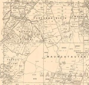
Extract from Maungatautari Survey District Map, T P Mahony 1933
The Pukekura Block was then leased in July 1870 to Thomas Douglas who, in turn, brought Edwin Walker and John Grice in on the deal. They already owned large tracts of land on the Roto-o-rangi side of the Aukati Line. However, a dispute over payment for the lease arose.
“Ani Waata, successor to Te Watu Tahi, a grantee, said: I received rent from Pukekura — £5 10s in 1875. I have received nothing since. I have asked for it from Walker. He said, ‘sell the land’. I did not agree. He did not give me the rent. I returned to the land because they would not pay me the rent.”
Other Maori owners also took up residence on the land, which led to the leasers destroying the owners’ homes and cultivations. The Land Court investigated the dispute in April 1881, and, as was so often the case, the Court found in favour of the leasers.
Ani Waata, Hori Puao, Tapu Te Whata and Tamehana, all legal owners, then took the dispute to the Court of Appeal in November 1883. Walker maintained that he paid the rent. “I sometimes paid half-yearly. I sometimes let a year or two run, and then they got that and a year or two in advance”. This dubious business practice, coupled with the maze of native land legislation, and the fact that these Acts were not translated into Maori, meant there was little wonder that confusion arose. There were no fewer than 25 Acts or Amendments relating to Maori land by 1883. The Native Land Court and its actions are still being unravelled today.
On 5 December 1883 Judge J. Richmond dismissed the appeal and charged “cost on the highest scale”. Walker forcibly evicted Ani Waata and the others on 17 February 1884. He arrived at 8 a.m. with his men and “accompanied by Major Green, Sheriff of the Supreme Court, the bailiff, Mr T. Howard, and further fortified by two mounted members of the Armed Constabulary” to take possession. A Supreme Court writ authorised Green to seize “all real or personal property” to pay the damages assessed by a tribunal at £800. Eighty-four horses, saddles, bridle, harnesses, buggies, plough and harrows were seized and auctioned in Cambridge. The legal wrangle dragged on for another two years.
How and when the land was eventually sold is unclear, but it was probably sold to Walker, to defray the costs of litigation. The Maori owners moved up the valley to settle at Kairangi, but over the years they drifted away and by 1896 Kairangi was deserted. Some would have moved to Maungatautari to live with their Ngāti Koroki whanau.
1800a
When the ownership of the Maungatautari block was first established in 1871, Pakeha land buyers began in earnest to procure the land. In 1873, E. Maclean and Co. purchased 8,000 acres. Ngāti Koroki retained some land at the foot of the mountain, around their kainga Tioriori, Taane, Te Wera a to Atua and Wharepapa.
The people still grew crops of maize, oats and potatoes, according to A. J. Allom, who visited the area in December 1873. The crops grown would have been cultivated to feed the visitors now, rather than trade. The flour mills lay idle and an effort to get them going again in the late 1880s failed.
Allom also reports that he saw great preparations for a meeting that was to be held in January 1874. The meeting was a very large hui, which was probably called to discuss land issues and to find solutions to the ever-increasing Pakeha encroachment onto the land. One such meeting in 1873 urged the people to “stop selling land, stop leasing land, stop road-making [and] stop erecting telegraph wires.”
Many such hui took place at Maungatautari during the 1870-1890 period. It had become the main centre for Kingitanga activity, so much so that by 1886 a bank — Te Peeke O Aotearoa — had been established in the area. The exact location of the bank has never been identified, “The bank was set up at Parawera [under the auspices of Tawhiao] and operated at Parawera, Maungatautari and Maungakawa.”
Right from the bank’s conception it drew ridicule from the Pakeha press. “The first account appeared in the Waikato Times 12 December 1885. Its supercilious, patronising attitude set the tone for much of the later writing.” These later accounts (probably all derived from the same source) say the bank was burnt down by unhappy investors after six months of operation. What actually did happen to the Maungatautari bank is lost in time, but a cheque of Maungatautari Peeke in the Cambridge Museum, is dated 17 March 1905.
Stuart Park’s “Te Peeke 0 Aotearoa” in New Zealand Journal of History rightly concludes:
“The Bank of Aotearoa was created to meet the monetary needs of the King movement and its treasury, and to express the financial autonomy of the Maori people. During its 20 year history it apparently filled these needs well … The cheques of Te Peeke .., enabled the transfer of money between the bank and its customers, sometimes in quite large amounts, without the need to move cash. Te Peeke 0 Aotearoa was a bank indeed.”
But by the 1890s the Native Lands Act and the Native Land Court had succeeded; the land that Ngāti Koroki had left was individualised into whanau blocks. A report by the Waikato Times travelling correspondent, in March 1892, stated that:
“Higher up the slopes are the native settlements where a considerable amount of grain had been grown this season. The Maoris are now abandoning their former communal habits. In the old days crops were grown and consumed in common, but now each family have their own plot of grain, and their own little stack…”
Here we find the beginnings of settlement as portrayed by Aunty Miri Tairi’s mural on the wall of Tirohia
1900
KO NGATI KOROKI, NGATI HAUA, NGATI WAIRERE
With the purchase of the Pukekura Block, there was no longer Māori occupation of the Karapiro area. During this century Ngāti Koroki have drifted away in search of employment. But hui such as tangi, weddings, 21st birthdays and land meetings draw large numbers of whānau who call Maungatautari home. Ngāti Haua are still concentrated around Matamata and Ngāti Wairere around Hukanui. Both Ngāti Haua and Ngāti Wairere continue to have strong associations with the area.
The Ministry of Works’ decision to build a hydro dam at Arapuni in 1924 helped to reinforce the relationship between Ngāti Koroki, Ngāti Haua and Ngāti Wairere when men from these hapū came to Arapuni seeking work. Work on the dam was completed in 1927. Horahora had been built before 1920 privately for the Waihi Gold-mining Company.
Karapiro was started in the late 1930s, but work on the dam was suspended in 1942 because of the Second World War. The dam was finally completed in 1947.
Taupua Winikerei, Tewi Tairi, Temera Heke Te Tirewi Tairi, Wina Tante, Tewha Winikerei Tuwhakaraua Taute, Percy Taute and Piiwhi Pouaka from Ngāti Koroki; Kingi Taui from Te Arawa; Tekira Davis from Whanganui; Pop, Harry, Peter and Bob Flavell, from Ngapuhi; Frank and Walter Smith from Tauranga, are some of the men who worked on the dam construction. They, along with their families, lived at the village specially constructed to accommodate the workers. After the dam was completed, many moved on to work on the next dam project. Maraetai (first generated power in 1952), Whakamaru (1956), Atiamuri (1958), Waipapa and Ohakuri (1961) and Aratiatia (1964) were all hydro dam projects on the Waikato River.
2000
KO NGāTI KOROKI, NGāTI HAUA, NGāTI WAIRERE
While only a few members of Ngāti Koroki still live at Maungatautari, Ngāti Koroki, Ngāti Haua and Ngāti Wairere continue and will continue to have strong associations with the area.
AHA KOA, KUA PU TE RUHA.
KUA HAO TE RANGATAHI
KO NGA URI O
TE IHINGARANGI
KA MAU TONU, MAU TONU,
MAU TONU PAIMARIRE.
Published as a series in the Cambridge Historical Society Newsletter with kind permission from Lyn Tairi during 2021 and 2022