
Learn Ako
Fun learning experiences for school visits, classroom sessions, heritage walks and for families at home.
Cambridge Explore
Waikato River
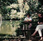
The Waikato River, flowing through Cambridge runs for 425 km from Tongariro north to the Waikato Heads and into the Tasman Sea. The first European river transport to Camp Cambridge in 1864 was a Paddle Steamer and crossing the river was done by punt.
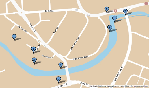
This trail takes you along the river starting on the town side, crossing the Low Level Bridge and continuing on the Leamington side if you wish to, returning via the High Level Bridge. It combines two walkways: the Settlers track (town side) and Soldiers track (Leamington side) and takes about an hour.
A printer-friendly version of the Waikato River tour is available here
There are steps going down on the Settlers track and steps going up on the Soldiers track, but there are alternative paths on the Leamington side. The Settlers track can be muddy after rain.
Town side (Settlers track)
- The Settlers track starts at Bath Street, and if you wish you can take a detour to the right to the Lola Silcock Reserve.
- The Lola Silcock Reserve was named after one of the founding members of the Cambridge Tree Trust formed in 1991. The Trust has transformed this area from rubble and weeds, and restores and plants many of the other green spaces around Cambridge.
- Major Wilson and the swimming area. The track continues to the left high above the river before dropping down a number of steps to the river’s edge. In 1885 an enclosure made of wire was constructed in the river for the purpose of bathing. Major John Wilson of the 3rd Militia gave permission for a pathway to be made through his property ‘Waterside’ to provide access. Wilson Street is named after him. The pathway later became Bath Street.Ladies were allowed to swim there between 4.30 and 7pm. After a second drowning in 1889, Major Wilson closed off access to the river, which was and is still a dangerous place to swim. Lake Te Koo Utu was also used for swimming (see Cambridge Domain Heritage Walk).
- The Victoria Bridge (or High Level Bridge) was sent out from Kansas, USA as a kitset and erected in 1907 from both sides of the river, meeting in the middle. It is 35.4 metres above the river. It was built in seven months and was the first braced steel arch bridge in Australasia. The official opening was on 21 December 1907. It wasn’t long before the motor car replaced the horse. In 1925 the softwood deck was replaced with hardwood and footpaths were added. In the 1960s the deck was replaced with reinforced concrete. In 2014 clip-on footpaths were added.
- Riverside Park: In 1864 it was decided that the 3rd Waikato Militia would be based here on the Waikato River in Cambridge. Later a redoubt was built in what is now Fort Street.The little bay where the Karapiro Stream meets the Waikato River was a place where steamers could turn around and head downstream. The current viewing platform is believed to have been built on the original foundations of the wharf. The army settlement was serviced by vessels such as the gunboat RANGIRIRI (shown below) and steamers PIONEER, BLUENOSE and DELTA.In the 1920s the paddle steamer MANUWAI (seen here) would travel between Port Waikato and Cambridge carrying freight as well as passengers. She could carry up to 400 people or 1000 sheep. Cambridge was as far up-river as vessels could travel.
- Karapiro Stream Bridge: Here the Waikato River takes a right hand turn and the Karapiro Stream veers off to the left. The first Karapiro Stream bridge was built in 1869, and this is the third bridge on the site.
- Low Level Bridge (Fergusson Bridge): The first bridge here was built in 1871 and was washed away in a flood in 1874, to be retrieved at Hamilton by the Armed Constabulary. This bridge is the third on this site and was built in 1964. Cross the two bridges to get to the other side of the Waikato River. Walk through the Kauri grove to get to the start of the track.
Leamington side (Soldiers track)
The Soldiers track follows the original cart track from the river’s edge to Cook Street.
- View of the landing: From here, you will see the modern version of this view. It shows the Army stores, a steamer at the wharf, with the Karapiro Stream bridge being built in 1869.
- Cattle trough: On the other side of the Victoria Bridge on Pope Terrace is an old concrete cattle trough. This was used by animals on their way to the Cambridge sales but also by pedestrians for cleaning mud off their boots before going to town.